Tag

british columbia

Browsing

Panorama Ridge is a breath-taking ridgeline snugly situated between Squamish and Whistler. It’s a challenging 30 km hike in the Garibaldi Provincial Park, just an hour and 15 minutes from downtown Vancouver. This hike caught my eye early on in February, but it’s not something you’ll want to do in that time! Conditions were perfect at the beginning of July: most of the snow melted, temperatures were outstanding, and a group of colleagues presented the idea to go with a group. Couldn’t say no to that!

As a relative newcomer to British Columbia and a first-timer when it comes to summer in Vancouver, I collected as much information and tips and tricks from people around me as I could. This is a hike you need to really prepare for!  Here’s what my experience preparing for and hiking Panorama Ridge was like.


preparation #0: experience

Before Vancouver, on average I probably went on a mountain hike about 4 times per year. For BC standards that’s not a lot, but combined with being a runner I guess this gave me enough experience and fitness to take this one on. To tell my legs to get ready for this endeavour, I went on a 15 KM hike the weekend before Panorama Ridge. The Diez Vistas & Lake Buntzen Loop was pretty good prep – would recommend it. 

preparation #1: day pass

First things first: get your hands on a day pass. To spend the day in Garibaldi Provincial Park, you need to set your alarm at 6:55 AM two days before you plan to be there. At 7 AM, the battle for day passes starts. After about 15 minutes, availability of passes was already low. Don’t forget about this important step! No pass = no hike. We went for the parking pass for the Rubble Creek parking lot.

preparation #2: hiking necessities

We went to the Mountain Equipment Company (MEC) to grab some very necessary items for this adventure. This is not an unpleasant errand – this store is amazing! It’s hard to spend only a little bit of time here. 

We went particularly for bear spray and bug spray, both very helpful to prevent getting eaten alive 🙂 Water treatment tablets were a much appreciated recommendation – you can expect some mountain water streams on the way, which means you don’t have to carry too much water (heavy bag!). We took about 2 liters nonetheless, just to make sure we’d not feel dehydrated before we’d reach the first water source.

equipment list

  • hiking boots with ankle support
  • water bottles
  • water treatment tablets
  • DEET bug spray
  • bear spray
  • sunscreen (body)
  • sunscreen (face)
  • hat
  • gloves
  • first aid kit (including blister bandaids)
  • toilet paper
  • wet wipes
  • camera of choice
  • energy bars

preparation #3: food plan

The next step is to spend the day(s) prior to your hike putting together your food plan. When we got back from the MEC, we baked a pile of pancakes (bacon & raisins, my fave!) as well as omelettes for some buns. More on our list: a couple of handfuls of nuts, energy bars, a stroopwafel (extra high on caramel, from the MEC as well), and most importantly: Pringles. The red, original can. Can’t go on a long hike without.

getting there

Set your alarm super early. You’re going to want to have the whole day for this hike. We were on our way at around 5.45 AM. 

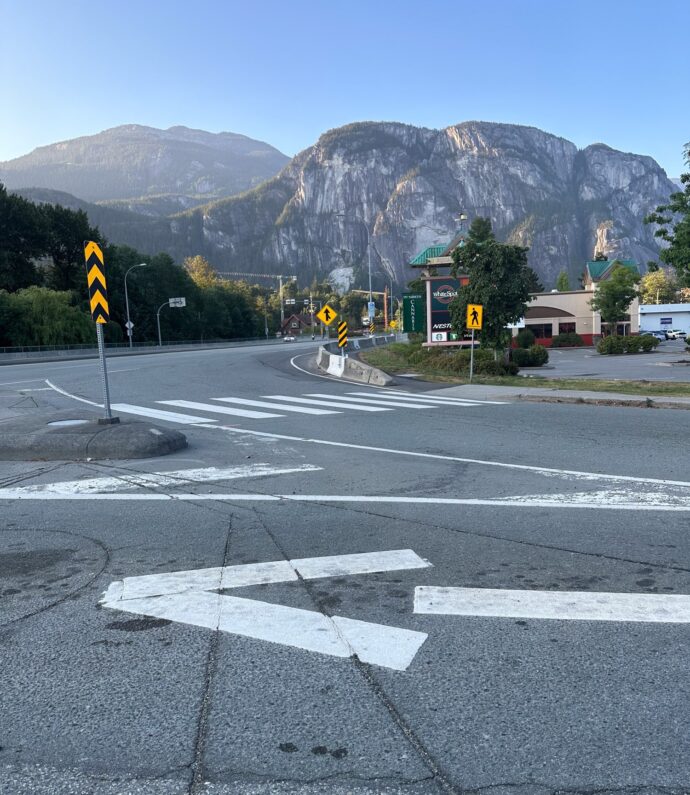
The sea to sky highway is an incredibly scenic drive, so if you ask me, the day starts there already! Once we reached Squamish, we grabbed a hearty breakfast at the A&W (McDonald’s-ish), and then went on to Rubble Creek, the start of the trail to Garibaldi Lake and Panorama Ridge.

When our group was complete and everyone was ready to go, it was somewhere between 7 and 7.30 AM. Let’s do this, people!

Squamish is so beautifully located!

panorama ridge hike

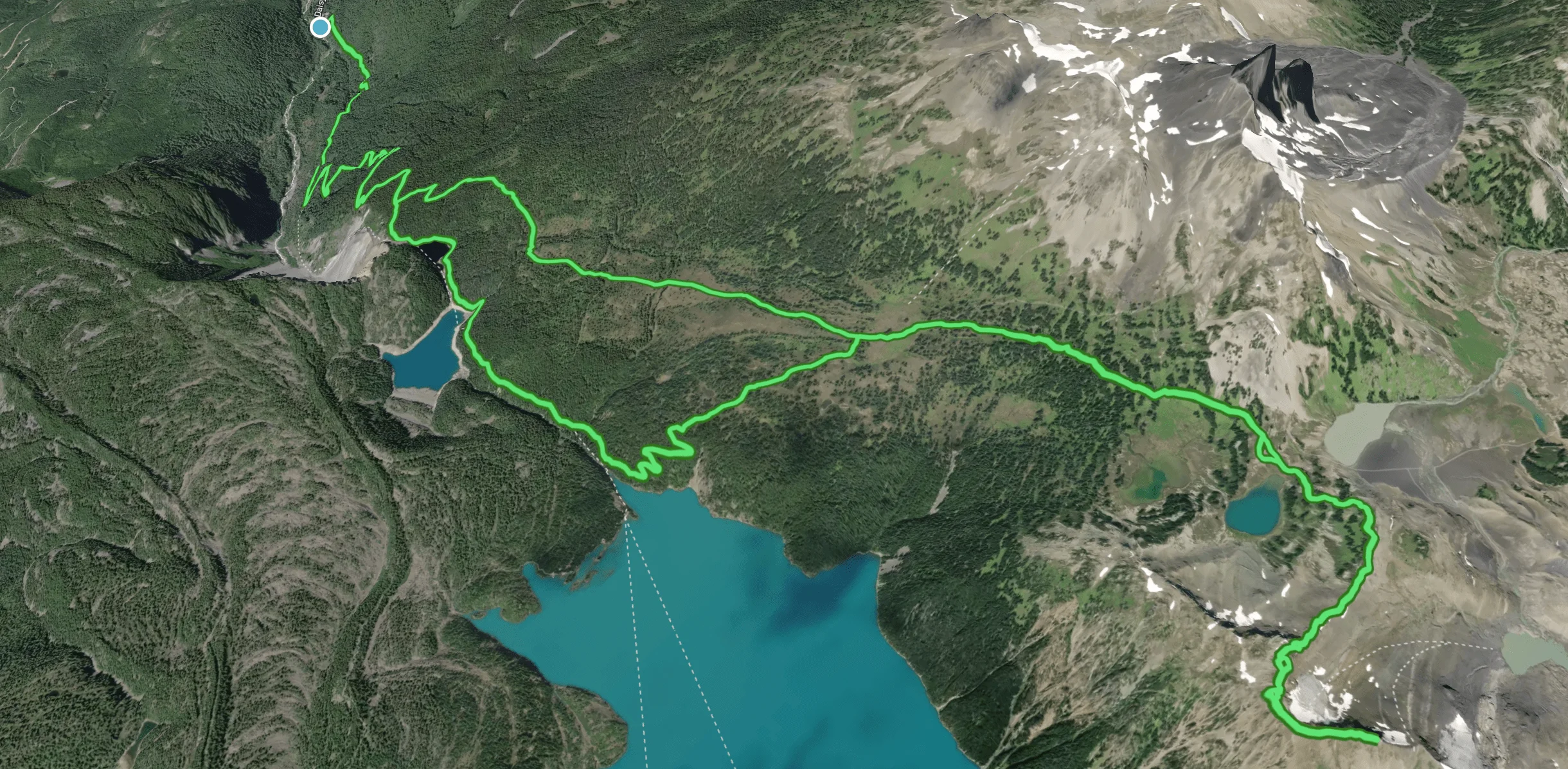
The hike starts with a steep introduction – your calfs are immediately confronted with quite steep trail in old-growth forest. After about 2 km, you’ll be treated with some switchbacks (17 of them, if I counted right). At the last switchback, you’ll have covered 4,6 km in distance and 661 m of elevation gain.

Not long after that last switchback, there’s an option to go left or right. The route on AllTrails goes right, sending you to the lake. Instead, we took a left, to the Taylor Meadows campsite. This would save us a little bit of time. On the way back, we would decide if we want to go back the same way, or make the trip to the lake. This would all depend on how much time we’d take covering the distance.

I particularly liked the part after that first junction, because after about 6 km in the forest, our surroundings changed and we could finally see the sky and look out more into the distance. The views were so, so nice.

A bit after our lunch break, at about 8 KM, we decided to split up into two groups. One group would double the pace and push to reach the ridge at no later than 3 PM, and the other group would turn right at the second junction to go and see Garibaldi Lake from up close. Both are incredible hikes, but the ridge would be an additional 10 KM to cover.

Joined by two guys from our group, Tom and I rolled up our figurative sleeves and made for the ridge. We felt pretty good and were positive we could do it! Lots of credit for that goes to the pancakes and omelettes 🙂

OEM02412-2
IMG_2756

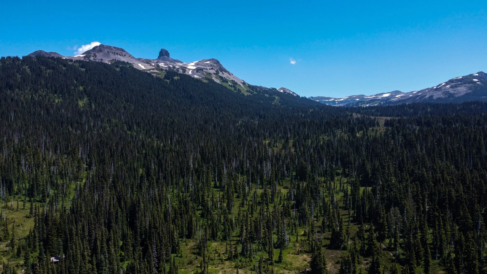
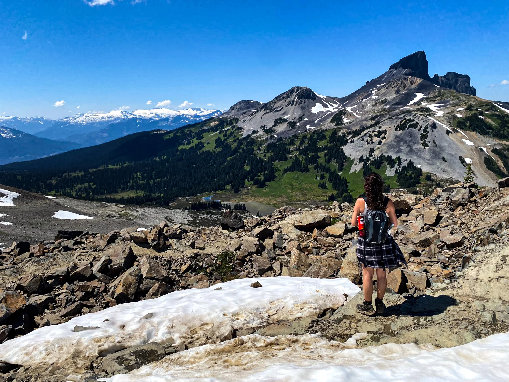
The hike from Taylor Meadows to the ridge was absolutely gorgeous. It was an incredibly bright day and visibility was super high. Stunning mountain views all around us. Alpine meadows, wildflowers, lakes, creeks… But man, it was tough. AllTrails was not kidding when it set the level to Hard for this hike. Below is a little video impression. Remember to keep breathing when you watch it!

Getting closer to the top, we found ourselves slowing down because we had to go through snow. 

And let me tell you a secret. I don’t like snow.

As we ascended further, we reached very rocky terrain and had to pretty much scramble for what was probably 45 minutes. At some point, I passed the snow, and only had rocks left to climb. Looking up, all I could see was bright blue sky and black rocks. So. Many. Black. Rocks. That all needed to be climbed to get to the ridge. For a second there, I wondered how many people tripped or accidentally stepped on a loose rock and fell all the way back down to the start of this hellish end game of the hike.

That thought was followed by a brief flashback to particularly unenjoyable Scottish munro hike in Glen Coe where I thought about 5 times that ‘this bit must be the peak’. Only to find out it’s NOT the peak and there’s more… THERE’S BLOODY MORE.

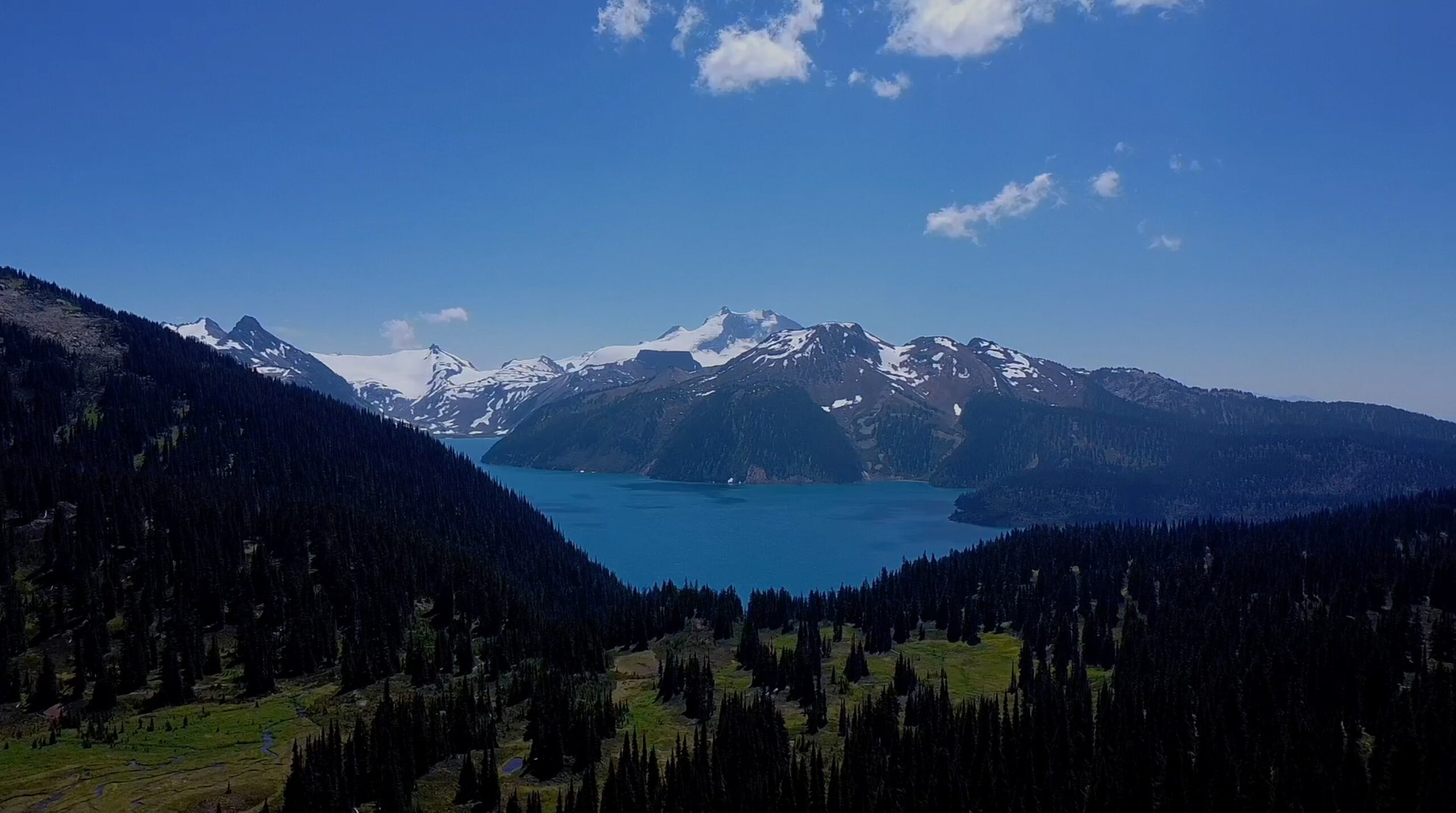
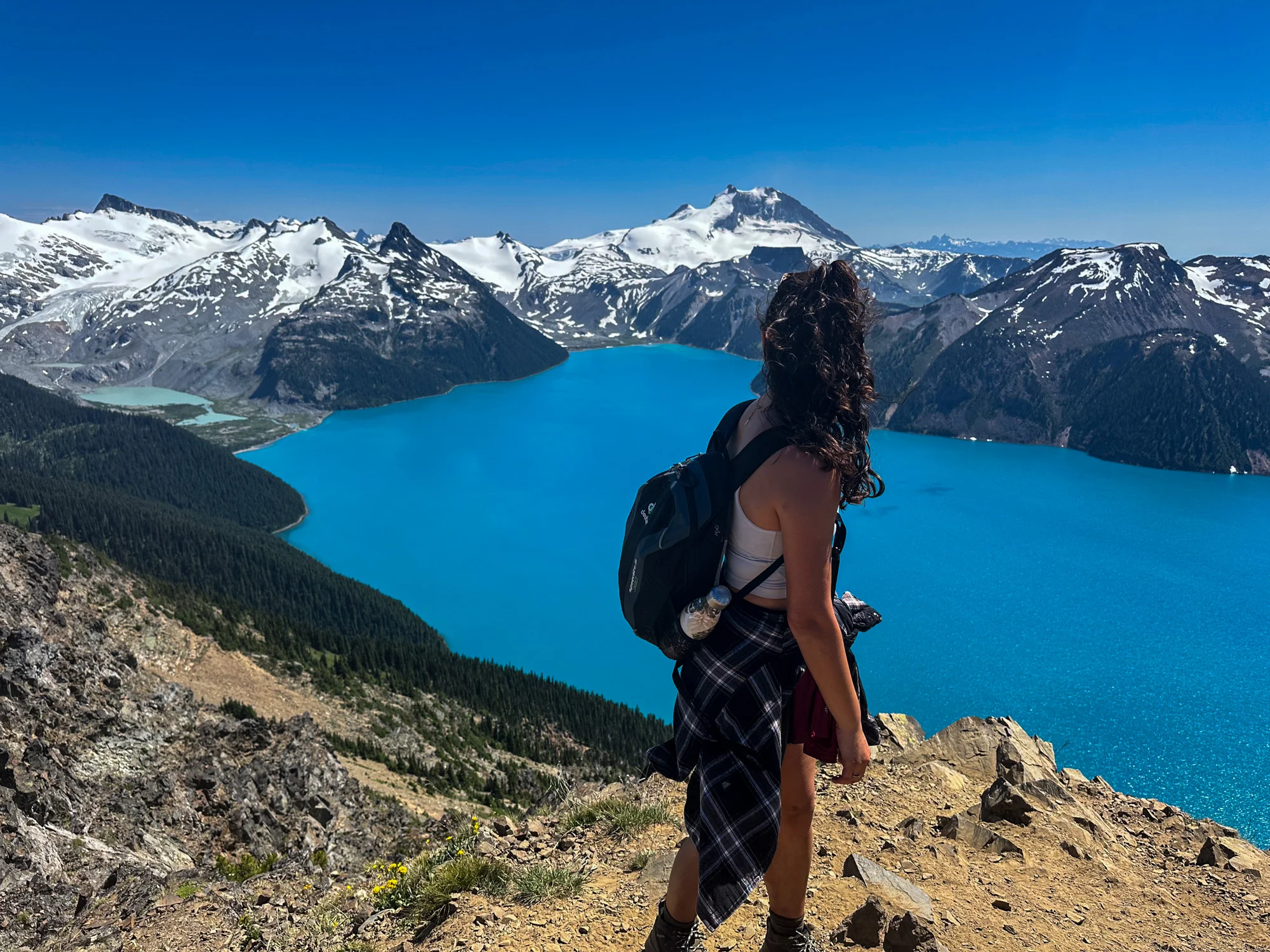
Anyways, it wasn’t as bad as that. There was only ‘bloody more’ twice this time. Then, with just a little bit more scrambling, it wasn’t just the blue of the sky, but a different out-of-this-world version of blue. Here we are. Panorama Ridge. When you see it, with the sprawling glaciers as a backdrop, you’re just rendered speechless. Can’t tell you for sure if it’s from sheer exhaustion or the utter beauty of that place. It’s just so surreal. You get an incredible 360 degrees view. If I had any breath left I would shout “Hello, Garibaldi Lake! You look fantastic from up here!” Instead, I just whispered it internally, sighed, and high-fived my husband.

four more hours

Looking back, my shoulders kind of droop realizing that after that whole journey, there’s another four hours in front of us to get back down. In the moment though, it was alright. I guess it’s that high and adrenaline of reaching that amazing view that got us back to the parking lot. 

Avoiding having to take all of those rocks again on the way down, we actually slid down a big patch of snow, which was kind of fun. (Despite the fact that it was snow.) My hands hurt from the cold snow I balanced myself on, but then I remembered I brought gloves, so the second section was easier – scrambling down over rocks and snow, I could hold myself upright with my hands without freezing my fingers off. I like to think the gloves saved my life, because without them, I probably would have fallen multiple times. It was so, so slippery! 

Once we were out of the snow and rocks and reached Black Tusk Lake (a beautiful lake just at the bottom of the climb to Panorama Ridge), we decided to take a bit of a break. It was much needed – we ate what we called an early dinner, and soaked our feet in the gloriously fresh water. Ahhhh that felt so good!

After that, the way back was very pleasant, but we decided not to take the route to Garibaldi Lake. I’ll have to come back to do that hike another time when we have hours to spare. The last 4km were gruelling. At that point, my knees, my ankles, my hips were all screaming at me – asking what on earth I was doing to my body. How much more of this torture? How much longer of this abuse to the knees, walking down hill for hours? Looking in front of me and behind me, I just saw my three hiking buddies having the same internal battle. Straight, focused faces. Nobody chatting anymore. Just focusing on getting this thing over with.

When we finally reached the parking lot, I was pure heaven taking my feet out of those hiking shoes. But it was so worth the blisters and sore muscles! They say we’re true Vancouverites now, with Panorama Ridge crossed of our list.

We reached home at around 10 PM, took a much needed shower, and then slept like the dead. 

One of the most important considerations when moving to Vancouver is which area to live in. The city has many different neighbourhoods that each have their own charm. For me, the search for the area that would suit my preferences ended in West End. It’s downtown Vancouver, but toward the western tip of the city center’s peninsula. I chose it for the combination of all the pros of downtown city life, but it’s quieter and super close to nature: Stanley Park, the beach, mountain views around, and quick access to get to those mountains. This is a rather expensive part of the city, so one might wonder: is it worth it? Here’s what it’s like to live in West End, Vancouver.

Located between Stanley Park and the center of downtown, West End is a beautifully situated neighbourhood. It’s a mix of high-rise apartment buildings and low-build blocks and even some impressive detached houses. There are rules in place that ensure this place doesn’t get too many more skyscrapers, and some of the older lower buildings are protected and won’t be making room for any developers.

Davie Street by English Bay
This is on Cardero Street, just before Robson Street. I love that street and how the buildings there are not so high!

This area it is a little quieter than the center of downtown, while still giving you that city lifestyle. Meanwhile, it’s very dog-friendly and family-friendly. I love how when you go out around lunchtime for a stroll, you’ll hear kids playing outside on the school playground and see people out for a walk with their dog(s) all around.

Vancouver is one of those cities with a straightforward grid layout. In this corner of the city, there are two streets toward downtown (from west to east) that you could consider the commercial streets: Davie Street and Robson Street. These streets are full of shops, services, great restaurants, bars… Similarly, we have Denman Street, which runs from English Bay to Coal Harbour (south to north). In between, you’ll find lovely residential blocks and a school. When spring comes (which is now!), the blooming cherry blossom trees make these streets look super quaint – you won’t feel like you’re in the middle of the city at all!

What contributes to that feeling for me as well is that West End is hugged almost all around by water: we’ve got English Bay to the west, Lost Lagoon to the north, and Coal Harbour to the north east. 

West End ends at Burrard Street – after that, you’ll be in the heart of downtown and beyond that you’ll find many more areas. In the rest of this post, I’ll share more about my experience with West End. I have not lived in other areas, so I can’t make any comparisons – all I can do is tell you why I love it here so much.

west end on the map

So what does that look like on the map? Below you’ll find a map of Vancouver with some of my personal markers included. All of these would be in a radius of just about 10-15 minutes walking distance. I’ll talk about some of these spots in the posts, but not all – it’s an interactive map, so feel free to browse and click around to read more.

[hmapsprem id=6]

english bay beach

One thing that makes it feel so chill here as if you’re not in a big city: the beach. Here in West End, you’ll find English Bay Beach, an open bay where you can dip your toes into the pacific ocean waters. The water there is actually called the Georgia Strait – far in the distance, Vancouver Island blocks the view of the open North Pacific Ocean. 

This beach is the first of a number of beaches as you walk along the sea wall around Stanley Park. I haven’t been here long enough to know what it’s like in summer, but they say it’s among the more popular spots to hang out and swim. So far, I’ve hung out there to enjoy a hotdog from the guy there (he only comes out when the weather is nice though) or a few tacos from La Catrina Tacos. If you look to your left across the water, you’ll look out over Kitsilano and its own beach.

denman street

This is where I go for our cheap go-to supermarket called No Frills (especially fruits and vegetables are more affordable here), to get my nails done, to enjoy a great lunch (Café Portrait, I love you so much), and to browse for some more great restaurants. You can find anything to eat there, from Japanese to Greek and from Vietnamese to Australian. When I work from home and feel like grabbing a bite to eat for lunch, this is the street I go to – I just walk and see which place screams my name the loudest.

The A-maze-ing Laughter sculpture looked extra interesting surrounded by snow!
Walking the Sea Wall after a snowstorm weekend
No matter the weather, this place is a lovely hangout!

davie street in west end

This very long street is where you’ll find lots of things. It’s my second stop when grocery shopping: Safeway is a more expensive store but they have the items I can’t find at No Frills. There’s a shop with house plants and flowers (a house is no home without plants), there’s the drug store, and of course… more places to eat. As you walk further on this street, you eventually go through Davie Village, a lovely area known for its LGBTQ community, Davie Street Pride Festival, and Davie Day celebrating the local businesses and Davie community.

You’ll notice that it gets a little busier as you reach Burrard Street, marking the end of West End. From there, it’s the middle of downtown and you’ll notice your surroundings becoming a bit more city-like with big office buildings, lots of entertainment, and businesses you’ll expect in a big city’s downtown area.

robson street in west end

Robson Street is the other commercial street that starts (or ends) in West End. This one feels steeper to walk over though – a real treat for the hamstrings 😉 Similar to Davie Street, this is a street full of businesses but this one is definitely known as the best street to go shopping. You’ll find stores like Zara, Sunglass Hut, Sephora, Footlocker, Lululemon, Roots, Lush. My favorite: Indigo, the bookstore! Fashion is terribly expensive though, so oftentimes I end up only window shopping. What else… Lots of cannabis, if you’re into that. Plenty more restaurants! Nail bars, hair dressers, some more supermarkets. You get the idea!

stanley park

If you’ve had enough of consuming and just want to enjoy nature, just head into Stanley Park. Either from English Bay or one of the other entrances. The park has so much to offer! All around it, you can walk or bike on the seawall – there’s a separate lane for cyclists. Or if you like running – run all around it and you’ll enjoy a beautiful 10K. If you go into the park, you’ll find so many things to enjoy. A rose garden, a rugby pitch, the aquarium (pricey though!), many lovely paths, benches and fields to relax, a brewery, a pavilion, a tea house… You can also find some scenic hiking paths there. There’s also a lovely souvenir shop with beautiful items! I bought a cute keychain there (new place, new keys!) and a book on Vancouver legends, but was so tempted to get more stuff from there. Keeping it mind for gifts!

surroundings

I took the drone out to film from English Bay Beach and give you a sense of the surroundings. You see the big green park and the mountains in the distance? Yup. And the beach and ocean? That’s all West End’s backdrop. It’s pretty astonishingly beautiful.

favorite local spots in west end

Those big commercial streets and highlights are nice and all, but it’s the smaller local hotspots that make this such a great place to live! Here are my favourite places in West End to grab something to eat and/or enjoy a cup of coffee. All three below are very locally situatied on quiet streets, in between houses and apartments.

cardero café

Cardero Café is an example of a super charming little spot. On a sunny day, go for a stroll through the neighborhood and stop at this Mexican-owned café for a coffee and a bite for lunch simply as a snack. The first time I ate here I enjoyed a chicken Tamal – sooooo good. They also have amazing paninis and good coffee. Such sweet people… I love it there. Grab something to go or have a seat in front of the café. It doesn’t stop there – they also sell groceries, so for any Latin American products, this is where you go and get your stuff.

greenhorn café

If you’d rather sit inside, Greenhorn Café on Nicola Street is wonderful as well. They have baked goods (their pistachio white chocolate cookie, YUM) and a mouth watering brunch/lunch menu. They also sell a selection of local foods and goods. I remember coming here for the first time a year ago when we were strolling around West End, fantasizing what it would be like to live in this area. We came to have lunch at the Greenhorn Café and were seated in the back section. They have a very cool vinyl collection over there that I just thought was so nice! Gave the place such a nice vibe.

robba da matti

I love (and I mean LOVE) Italian food, so having Robba Da Matti so close by is super nice! It’s a really charming place with a beautiful patio that I would love to try next time I go there. What I love about this place is the overall ambiance inside – such lovely warm and dim light that just gives a beautiful and romantic feeling to the place. The food there was so, so good. They had ossobuco with saffron risotto on the menu – that’s one of our favourite dishes and almost a Christmas tradition for us. I had a seafood spaghetti – it was out of this world. So good. Mouthwatering just thinking back and writing about it.

Robba da Matti - A beautiful restaurant with a lovely patio. Can't wait to spend more time here in the spring and summer!
English Bay Beach walk on a lovely February day
Cardero Café has a cute little patio with four corners where you can enjoy your order
Greenhorn Café on the left and Nicola Dry Cleaning on the right

the bus

West End is lovely, but let’s also talk a bit about how you can get out of here to explore more areas in Vancouver. I’ll use the stops on Davie Street near English Bay here, because it’s a convenient starting point. On just a few square meters you’ll find bus stops for the 5, 6, and 23.

  • Take the 5 to Downtown – it goes over Denman and then turns onto Robson. Wherever you need to be for your downtown shenanigans, this bus is perfect to get you there. As I mentioned, Robson is a popular shopping street, so if your activity involves shopping, this is the bus you’d best take. We also take this bus to 413 Seymour street where we get our car rentals. Or to Gastown for nights out involving live music.
  • Take the 6 to Downtown to get to Burrard and from there you can switch to another bus taking you over the bridge down to Kitsilano. This bus goes over Davie Street.
  • Take the 23 for a route along the water. This is a good one to get to Yaletown, Fairview, Mount Pleasant.
  • You can also walk over to W Georgia Street (on the maps here this is that grey 1A road going into Stanley Park and the bridge beyond it), where you’ll find a busstop for buses 19, 240, 241, 246, 247, 250, 253, 254, 257, N24. These buses will take you to North Vancouver, from where you can hop on other buses to get further up north. Don’t be surprised if you see people waiting at that bus stop with their skis or snowboard on their backs, or wearing their hiking gear and big backpacks, because this is like a gateway to mountain adventures! (Such as skiing or hiking walking in Whistler or hiking in Lynn Valley!)
You can see downtown in the distance... But it's not far at all, just a 20 minute walk!
Comox Street looks unreal with the cherry blossoms!
Buildings vary from single to around 30 floor flats. This is a medium sized one. The buildings generally look very neat and streets are very well-kept.

With a long weekend on the calendar this month, we started February looking around for a nice first multiple-day trip away. Though we initially entertained the idea of a Seattle visit, we decided on a road trip to the Okanagan Valley. We’d heard so many great things about it, it was high on our list! A lovely 4,5 hour drive through British Columbia, it promised to be a trip with lots of spectacular views. And it sure was! Here’s how we spent Family Day Weekend.

renting a decent car

With the weather conditions this time of year, we got ourselves a midsize car to make sure we’d feel safe out there in the snowy mountains. We hopped on a bus in the morning to the rental pick-up spot downtown and were on our way fairly quickly. It was my first time driving in Canada!

kelowna

First stop: Kelowna. Located on the east shore of Lake Okanagan, it’s a lovely little city (population: 132,084)  surrounded by beaches, mountains, and vineyards. It’s also known as a very sunny place, with an average of 2,000 sunshine hours per year… With these ingredients you can see how this is a popular spot for vacationing and lots of outdoor activities.

We came to have lunch at a spot I was recommended to check out. As a bread-lover, Sprout certainly didn’t disappoint with its freshly baked goods! I’ve got to tell you, bread in Canada is generally pretty bad, so places like these make me very happy. Off to the right side of this amazing lunch restaurant was a special corner for Slowside Coffee, a beautiful specialty brew bar serving only premium coffee. If you’re a coffee lover, this is a must visit.

After lunch, we walked around a bit and enjoyed the view out at the beach. That Saturday didn’t contribute to Kelowna’s sunshine hours so much, but cloudy weather combined with mountain views still make this place beautiful.

We hopped into the car to go to… the mall. Now, hear me out, I know that’s not what you’d imagine as a top activity when you’re visiting such a nice area. But Mountain Warehouse had a huge sale, and we had some ski gear to buy!

The Waterfront Park and beach in Kelowna. Such nice views!

penticton

Next stop: Penticton. It under an hour, we reached this lovely town (population: 33,761) situated between two lakes. Lake Okanagan to the north, and Skaha Lake to the south. When we first heard about Okanagan, it surprised us that so much great wine comes from this area. It’s those sunshine hours I was mentioning earlier that makes for great conditions, and Penticton alone has around 50 wineries! Just like Kelowna, it’s known for its hot summers and dry winters, and we were told that in summer this place is buzzing (or as the lady at the winery even said: chaotic).

We were happy to have our Airbnb here. We unpacked, relaxed, and looked through the restaurant recommendations our hosts had left us. Refreshed, we walked onto the main street of Penticton. Passing a very nice-looking restaurant, I looked up to see what it was called, and a man standing nearby saw my interest. “Have you eaten there before? That place is absolutely amazing,” he said. “Soooo good,” he added. 

He was right. Thanks for dinner, Wild Ginger!

The view at Kelowna's Waterfront Park

skiing

After a good night’s sleep, it was time for action… Finally, it was time for us to learn how to ski! We drove out to Big White Ski Resort, about 1 hour and 45 minutes away from Penticton. Big White Mountain is the highest summit in this area (2,319 m) and a popular ski destination. We got a Discovery Beginner Lesson of 2 hours, including rental for all gear (skis, poles, boots, helmet), and a lift pass, for $109 per person. This is very affordable compared to Whistler, where you pay $200 just for a pass for the day.

We had our lesson with two other beginners and a British teacher to show us the ropes. I’ve once been told that if you’re good with ice skating, skiing should be relatively easy. I was sceptical considering my clumsiness, but surprised myself (and Tom) with how quickly I managed. And without any falling!

Very hungry after our lesson, we took the gondola back down to the village for a meal. Taking advantage of the last bits of daylight, we went back up to the gondola as quickly as possible to see how well we’d do without our teacher. In that adventure, I was reminded not to use kids as a reference point – seeing a few little ones go down a slope, we decided to try that one as our first try…

IT WAS SO STEEP. IT WAS SO LONG. IT WAS SO FAST. And I fell so hard.

It was bound to happen at some point, right? After getting back up and finding my right ski in the snow, I continued down and found Tom at the bottom actually about to find a way up to come find me because I was taking so long :’)

We went back up again to try one more time. This time around, I got a little bit further, but lost control again and fell even harder than the first time. Ouch.

More bad luck: I was so eager to see the footage of my GoPro and see how I fell. Turns out it stopped filming after 15 seconds. The second one it didn’t even film at all. Damn it! It would have been so funny to hear myself scream. Especially that second fall took so long – thinking back I giggle at how long I was squeaking (and swearing), trying to slow down and regain control over my skis, before finally slipping, dropping, sliding, and coming to a stop grunting.

I was fine – didn’t break anything thankfully!

Driving out of Big White was a bit scary – it had snowed all day and it had not stopped. The roads were slippery and visibility was so limited. We were so glad about our great car! Completely spent from skiing, falling, and driving in those conditions, we called it a day not long after coming home to our Airbnb.

Flying the drone on Copper Mountain

wineries & weeneries

As a wine-lover, I couldn’t spend time in Okanagan and not do at least one tasting! There was a good one right in Penticton where we were staying. So on our last morning we drove out to Poplar Grove and got to taste 6 of their wines. They were great – especially the whites! We got ourselves a couple of bottles of our favourites and were on our way.

On a funny note: as we were raving about how many wineries there are in this area, we saw a restaurant that proudly called itself a “weenery”. 

It was a sausage restaurant.

hello, drone

With so many kilometers to cover on this trip, we took out the drone I got for my birthday last summer! It had been a while since I last flew it. We took a different route back to Vancouver – via the south this time – and it was a good thing we did… In between and after the stops where we filmed with the drone, the weather conditions were so bad and treacherous! Turns out, the route we chose not to take was much worse and there was an alert out warning people not to take those roads. Whew!

Well – we made it home without a scratch and have a lovely weekend to look back on! Below is some of the drone footage. As we take more trips I hope to get better at flying it and collect more of these breathtaking videos. Looking forward to the next weekend trip!

It’s winter time, so many people are out enjoying their skiing skills – which I don’t have… yet. After a wonderful day exploring the lakes in Whistler, I went looking for other hiking destinations. Ones without snow dominating the views so much. It turns out that’s actually not impossible, so one beautiful Sunday morning (29 January) we rented a car (just $40!) and drove out to Anmore. Just a bit north of that town, we found Buntzen Lake

Buntzen Lake is a hydroelectic reservoir that once served as Vancouver’s main source of electricity. Arriving at the parking area, I could already tell this was going to be beautiful! The lake is surrounded by several mountains, including Eagle Mountain at 1240 meters and Buntzen Rudge about half of that. Here’s me below smiling because the sun was shining and we were at a beautiful Canadian lake on a random Thursday 🙂

diez vistas trail at buntzen lake

To the left of where this photo was taken we went into the forest and soon found the beginning of a trail. It was probably around 10.30 in the morning and the sun was shining so beautifully into the trees! After crossing a floating bridge over the eerily dark water (guys, I’m not good with dark-looking and deep water), we found the signs for the trail we were looking for: the Diez Vistas trail. Unfortunately, we also saw a sign indicating it was currently not possible to walk a full loop as a crucial bridge on the other side of the lake was closed. But that was okay – our intention was just to give it a go and see how far we’d get anyway. 

Gorgeous sun beams shining through in the forest!
It was such a clear and bright day. The reflection on the water was stunning!

The trail was classified online as an intermediate trail, but my gosh, it was definitely hard on quite some parts! Caught myself thinking “okay don’t look down here” and “I’m dead if I slip here” a couple of times there.

Quite some climbing, my Garmin watch telling me I’ve reached my stairs-goal ten times over, and also some nice hellos and you’re almost there!s from people coming back down. 100% worth the effort of course – after some tough switchbacks we reached the first two viewpoints which overlooked Sasamat Lake and Belcarra Regional Park. In the distance, we could very clearly make out Burnaby and Vancouver.

Reaching this viewpoint already took us about 2 hours. As daylight is quite scarce this time of year (sun is down by 5) and the way back would be challenging with the steep trail and slippery mud, we decided to head back so we’d have some daylight left. We’ll definitely return in spring or summer to do the full hike so we can see all 10 viewpoints – hopefully the full loop will be accessible again by then as well!

maple ridge

We wanted to take advantage of having the car some more, so we drove further east to find a nice restaurant. We found Kingfishers Waterfront Bar & Grill in a town called Maple Ridge, drank our first British Columbia wine (delicious) and enjoyed dinner very much. Lovely spot there, overlooking Fraser River. After we’d no longer been looking at the river but just darkness, and we were super full, we drove back. Returned the car, and found our way back to our apartment. Because we live here now – WHAT? Still getting used to the idea that we’re not just here on vacation!

driving

I should mention, driving is lovely. The surroundings over here in British Columbia are stunning. All these mountains around, snowy tops, national parks, lakes, everything. Felt sorry for Tom that he had to keep his eyes on the road. Speaking of driving – we can keep using our Dutch licenses for now, but eventually we’ll have to get a BC license. We met a few lovely couples here from different countries and some of them had to go through costly knowledge tests and driving exams (which, apparently, guaranteed you will fail on the first try). Thankfully, coming from the Netherlands, we’re exempt from all that hassle and it will just be a bit of paperwork. Lucky us!

more more more

Don’t get me wrong, I’m okay with some snow, but I like alternating a bit. It was nice to leave my huge warm jacket in the car this time. For next time, you can expect some more winter wonderland vibes, because there’s a long weekend coming and we’ve made some plans!

Everybody here talks about it: if you’re going to be a Vancouverite you can’t sit around and ignore the ski culture. Everyone skis. You learn this very quickly (alongside these other 6 things). You’ll see people carrying their snowboard or skis on their shoulders on their way to a bus stop in the city. It’s literally just a 1 hour and 45 minute bus ride to Whistler! I have yet to learn how to ski, but was curious what made Whistler in particular so special. As I have zero snow skills, I didn’t want to pay $200 for one day of skiing (which is literally what a day pass costs), so for now the plan was to see the town and explore the area.

whistler village

We had booked a very early (6:20 AM) EpicRides bus to Whistler for $43 (round trip). When the sun started to rise, the mountains were an incredible sight in the early morning light! Once we arrived at the bus loop, we followed the crowd into the village. It’s a charming little centre with restaurants, bars, and shops. Watching people around us full of anticipation for their day in the snow was like watching Disney figures happily skip through the forest with birds singing on their shoulders. Couldn’t blame them – it was a gorgeous morning and the weather forecast for the entire day was perfect.

We started our day grabbing a map at the visitor center and having a closer look at it over a coffee. Estimating roughly how long it would take to walk around the area, we decided to go and see what the lakes around Whistler are like. As we didn’t bring our hiking shoes (and you’d need more serious gear in these conditions!), we went for walking trails.

lakes in whistler

We started walking toward Lost Lake, a small lake with a park and beach. It’s supposed to be really beautiful and open year-round. The further we went out of the village, the more snowy the paths got. A true winter wonderland, we enjoyed the crisp air, the huge trees, and the surrounding snow-covered mountains. Unfortunately, Lost Lake turned out not to be accessible at the moment unless you were nordic skiing. We decided to turn around and head to the biggest lake instead, which was Alta Lake, to the west of the village.

By the time we were on a trail around Alta Lake, quite some time had gone by, and walking around the lake itself took us around 2,5 hours. Some paths were made snow-free, other parts were icy or had thick layers of snow. Wintery beauty was all around us, so we stopped often for pictures and taking in all the sights. The weather stayed sooooo good throughout the day – it was 3 degrees but bright and sunny!

Whistler Village, a charming centre with lots of restaurants, bars, cafés to enjoy
With the sun shining the photos of Whistler were extra special! Here's Tom on the ice while I got anxious thinking about the water below him.

holiday seasons in whistler

On the way we saw such beautiful neighbourhoods with lovely houses in the mountains or by the lake. If we didn’t see people walking around, they’d be running, or nordic skiing with their dog(s) running alongside them. Also: houses that obviously looked like abandoned holiday homes… Perhaps they belonged to people that prefer the lake in liquid state! It was a bit hard imagining what it would be like in summer, with the lake completely frozen over and covered with snow… But Alta Lake actually has three beaches which are very popular in summer. I’m told summers in BC are absolutely stunning so I guess it’s not surprising that people like to come up here!

Once we reached the furthest tip of Alta Lake, we had finished most of our food, so with our empty backpacks we looped back via the other side of the lake. I must say the view over the lake is much more impressive from the west overlooking the east than the other way around. But it’s all beautiful nonetheless.


A snowy bridge in Whistler

enjoying the village

Back in the village, we took a table on a patio under a heater and ordered a poutine to share. It was delicious! After a while, the entire patio was filled with people, and the village was buzzing with folks re-energizing after a day on the slopes. As good as this restaurant was at poutine, they were just as bad at steaks… That was a bit of a bummer 😉

We strolled a bit more through the village, visited some shops, added a Whistler mug from Starbucks to our collection, and laughed at some seriously funny t-shirts. With 1,5 hours or so left before our bus ride back to Vancouver, we went to Earl’s Bar & Kitchen (popular chain here) for a drink until it was time to head back. Arriving at the bus loop, we had the funniest bus driver welcoming us in and waving us off once we were back in Vancouver. 

is it worth (it without) skiing?

So… As non-skiers and walking/hiking lovers we had a great time. The mountains are huge and stunning. I’d imagine the weather conditions can make or break the experience – the sunny weather made it amazing, so check the forecast for the best day in the week. There are more options than just walking around though. You can buy a sightseeing day pass and take the gondola up the mountains. You can go snow tubing, or even snowmobiling (like a snow scooter). There’s a distillery to visit as well. Plenty of options, but you should try to book it in advance. We went without much prep, knowing we can return easily by bus if we want to.

As I’m currently not much of a snow enthusiast, I’m not sure I’d find it worth $200 to ski in Whistler when there are other more affordable skiing areas close by. But I can imagine that if skiing or snowboarding is in your bones, this would be a bucket list destination. It was the 2010 Olympic Winter Games location after all! Once I’ve taken (a) lesson(s), I’ll have to come back to give it a shot to really see if it’s as amazing as they say. I’ll let you know when that moment comes! 😉

Quite often I grab my phone while watching a television show or movie, in awe of landscapes. “Where was […] filmed?” would be my Google search. And then the result would be: British Columbia, Canada. Ha! With so many great productions filmed in British Columbia, #hollywoodnorth is a recurring category in which I share my fave shows and movies shot in B.C. Today: two movies and six actors that may ring a bell: Milo Ventimiglia, Amanda Seyfried, Ryan Reynolds, Jennifer Garner, Ryan Ruffalo, and Zoe Saldana.

The Art of Racing in the Rain

Originally a 2008 novel by Garth Stein, the film adaptation of The Art of Racing in the Rain was a must-see for me because it combined three perfect ingredients: Milo Ventimiglia, Amanda Seyfried, and a Golden Retriever named Enzo (Kevin Costner). Enzo narrates this film, telling us all about his adventures and life lessons as the best friend of his race car driving master Denny. It’s an emotional drama movie that will make you laugh and cry and love dogs more than you already do. The original movie description reads:

Shot in Canada, the US, and Italy, the movie started its filming process in Vancouver and surrounding areas. Denny meets his future wife Eve grocery shopping in Port Coquitlam (30 minute drive from Vancouver) and trains on the race track in Mission (1 hour drive from Vancouver) at the Mission Raceway Park. Closer by, Eve takes a hike in Princess Park in North Vancouver. It’s an important scene that they filmed there – a worrisome turning point in the movie concerning Eve’s health. Milo Ventimiglia was also spotted filming in Coal Harbour in the city of Vancouver – you see a glimpse of it as he takes Enzo for a run. Watch it on Disney+ or rent it on Amazon Prime and remember to have a box of tissues within reach.

[hmapsprem id=1]


The Adam Project

Next in today’s #hollywoodnorth post is the 2022 action sci-fi comedy in which young actor Walker Scobell stars alongside Ryan Reynolds, Jennifer Garner, Mark Ruffalo, and – one of my favourites – Zoe Zaldana. In this time travel story, fighter pilot Adam from the year 2050 accidentally ends up in 2022 with a stolen jet and runs into his younger self. They work together to save the future, but not without some hilarious witty and snarky conversations and some heartwarming moments for both older and younger Adam. Enjoyed this movie a lot – lovely action film to watch with the fam!

Ryan Reynolds is a proud Vancouverite, so it must have been nice for him to be shooting this film in his home town! Locations include the Blarney Stone Irish Pub and the Lower Seymour Conservation Reserve. This latter location was used for the woods around Adam’s house and definitely a place I would like to explore. With over 65 km of hiking trails that I can get to in just a 30 minute drive from the city of Vancouver, I can’t not go and have a look on the weekends! 

Another filming location was the Chemistry Building on the University of British Columbia campus. I happen to know this building as it was part of the campus tour I got back in March when I was there for work. That’s one filming location I can tick off my list already! 

And finally, I am also particularly interested to see Alouette Lake (image below) – apparently a much loved campground. From the photos I can see why…

Photo by Lauren Kan

[hmapsprem id=2]

With just 2,5 weeks until my flight to Canada, I look forward to visiting some of these places and shoot my own photos of all those beautiful spots… See you next time with two more movies or shows shot in and around Vancouver!

Quite often I grab my phone while watching a television show or movie, in awe of landscapes. “Where was […] filmed?” would be my Google search. And then the result would be: British Columbia, Canada. Ha! With so many great productions filmed in B.C., this post is the first of a recurring category called #hollywoodnorth (which Vancouver is also known as) in which I’ll share my fave shows and movies shot in British Columbia. 

see

Allow me to start with my favourite. See is a show available on Apple TV+ that I started watching in 2019. I have to admit here that I really only started an Apple TV+ account due to my free subscription that came with my new iPhone back then. I was planning to end the subscripion after a year but I’ve been keeping it. And the only reason is… See.

Bold statement here: this was one of the best science fiction stories I ever saw. I should follow this up with a disclaimer too: I am by no means a science fiction connaisseur. Feel free to send me something you think is better or comparable after you have watched it too. But I’ve been soooo fascinated by this story from the moment I read the description, right before starting the first episode. I’m obsessed. With the show and with how Jason Momoa was the only actor who could ever do this role. Seriously. He’s perfect.

The story is set in a post-apocalyptic future where centuries of generations have been blind. The concept of sight is completely mythical to everyone alive. All that society knows is that people’s ability to see had destroyed the world centuries ago. Following a small tribe, the show starts with the twins Haniwa and Kofun, fearfully keeping the fact that they are not blind a secret. Until they find out they are not the only ones that can see (gasp). A hunt on these sighted ‘witches’ starts: society is totally threatened by these dangerous creatures because of this incomprehensible power to know things that are impossible to know. How could one possibly know what lies ahead at the end of an unknown road? How could one possibly communicate without hearing or touching? How could one possibly know a surrounding when they have never been there before?

But these hunters won’t get to these kids so easily, because their dad is Baba Voss (Jason Momoa) and, obviously, anyone would have to go through him first. Good luck trying.

The show was filmed in British Columbia and Ontario. The scenery is insane. Even more insane is how everything is set up. Informed by people from blind communities, the show is full of incredibly impressive details. How would a blind society build its towns and cities? How would they communicate? How would warfare be organized? How would people talk and refer to each other? How would people travel? What would their understanding of history be? I’m so impressed by how they have imagined this world. And… also saddened at how realistic it is that in this story, centuries from now, there would still be a constant fear for people that are different. And at how if you would take away sight, people would still find something else to discriminate on. 

Sorry for that depressing part. 

On a brighter note. The villain in the show is a Dutch actress and she is amazing.

One last thing. The fighting is brutal. Absolutely brutal. BUT SO GOOD. 

OK. End of fangirl raving about See. Go watch it!

Here’s a map with some spots I’m dying to see. This article was very helpful in identifying filming locations.

[hmapsprem id=3]

virgin river

I know, you must be getting a whiplash here, but from post-apocalyptic brutal action and science fiction, we’re moving on to romantic drama Virgin River. 

For some lighter television, I’ve been watching Alexandra Breckenridge (US) and Martin Henderson (New-Zealand) play a super cute couple in a beautiful fictional Californian town called Virgin River. You guessed it, Virgin River is not in California at all – it’s actually Vancouver and several places in British Columbia

Originally a book series written by Robyn Carr, Virgin River is about Mel Monroe – a nurse practitioner looking to start over after several traumatic events in her life. She lands a job at a small practice in a remote town in northern California and says goodbye to her city life in Los Angeles. Virgin River turns out to be a lovely place – not just for its beautiful location but also for its strong community. Being new in town comes with its challenges though. Insert a handsome guy with some issues et voilá, we have a romantic drama that I can binge. Sappy as all this sounds, I’ve enjoyed watching this show quite a bit. The scenery definitely contributed to that. 

Sadly, my current only way of visiting Virgin River is Netflix but I can’t wait to visit some of the locations myself soon! One of them would be Squamish, just an hour drive north from Vancouver, where you can find Jack’s Bar from the show. THOSE MOUNTAINS! I simply must to go there. I mean… Seriously, just do a quick Google images search on Squamish mountains and you’ll get it.

There’s so much more coming. Next time, another two shows that I love that were shot in and around Vancouver!

Hi! I’m Indira from Rotterdam, the Netherlands. In a few months, I am embarking on a very exciting journey… I’m moving to Canada! It still feels so surreal to say it, but the colder it gets outside, the more I realize that my departure date is coming closer. Shortly after the New Year, I’ll be hopping on a plane to Calgary and continue down to Vancouver. Would somebody pinch me?!

hello, welcome to vandira

Back in the day, in my teenage years and early twenties, I loved blogging and journalling. I always had a camera within reach to capture everything around me. I have such a big photo archive from that time! As I lost the rhythm of blogging and started to focus on other things, my photo archive was no longer expanding as much as it used to. 

With such exciting things ahead of me now, I’ve felt super inspired to build a blog again – it’s such a nice way to capture special moments and share experiences. So here I am, with vandira.com as my little corner on the Internet where I can document my experiences. For myself, for my dear friends and family back home, and for anyone else interested in how I cope with living abroad!

british columbia

After a trip to Vancouver back in March 2022, I was so sure that this was the area. The tiny bit of British Columbia I saw during that short trip was so breathtakingly beautiful! I can’t wait to familiarize myself with Vancouver as a local and see much more of BC! 

On a gravel path overlooking the ocean at Uclueluet, Vancouver Island
Ucluelet, Vancouver Island, British Columbia, Canada | 28 March 2022

The picture up here was taken on Vancouver Island on a day full of hiking and discovering beautiful towns and staring at gorgeous views. I can’t get over this place and its mix of everything I could wish for in terms of nature and how this area is situated. The city, the ocean, the mountains, the beaches, the wildlife… All of that so close together, yet this place is massive! Am I really moving to Canada? WHAT?

reality check

OK, before anything else, let’s take a step back and do a reality check (or, better phrased as what the heck am I doing?).
  • I sold my house (cry)
  • I resigned from my job (cry cry cry)
  • I got rid of a lot of stuff (not so much cry)
  • My home country is 4% of the size of British Columbia (gulp)
  • My home country is 0,4% of the size of Canada (are… are you getting this? My home country fits into Canada almost 240 times!)
  • Meanwhile, Vancouver’s city is just 35% of the size of Rotterdam. Maybe this is what makes the idea of living in Vancouver more manageable for my brain to grasp (sigh, I love Vancouver)
  • I can’t bring my two kids. I’m leaving them in the Netherlands to fend for themselves.
  • Just kidding, I don’t have kids. I have two cats and they will be staying with their grandparents (CRY!)

Looking forward to sharing my journey toward and in Canada with you all here! See you next time!